
Description
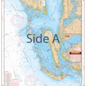
This single chart gives you both the coverage and the detail necessary for this busy area! Coverage of the inshore and coastal waters from western Dauphin Island, Alabama to Cat Island and Gulfport, Mississippi. Covers up to 22 miles offshore to include the northern Chandleur Islands. Shows the route of the Intracoastal Waterway from Statute Mile 70 to past Statute Mile 115. Details on Side B for Pascagoula and the Pascagoula River as well as Biloxi and Back Bay of Biloxi. The details are compiled from small craft charts and are exceptionally easy to read and understand. 29 GPS Waypoints are positioned to make it easy to set up your electronics and to follow the ICW or enter the harbors and passes between the Islands. Information from 3 NOAA charts: 11372, 11373 and 11374. WGS84-World Mercator Datum.
25″ x 38″
25″ x 38″.

Reviews
There are no reviews yet.