_Navigation_Map_62_Side_A")
_Navigation_Map_62_Side_B")
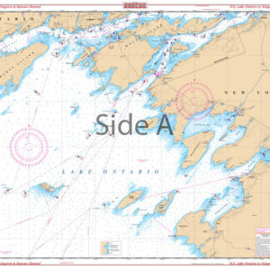
New York Harbor (Manhattan) Navigation Chart 62
The Area Covered
$32.95
The best chart for the New York City area combining information from five government charts! Covers Sandy Hook Bay, the entire Lower Bay and Raritan Bay, Staten Island, Brooklyn, Jersey City, Newark, and lower Manhattan on one side. The reverse side covers the East River through Hell Gate and out past Rikers Island, under the Throgs Neck Bridge to Kings Point, as well as the Harlem River north to the Hudson. Colored key and panel designations and large print place names make this chart easy to use.
Out of stock
The Area Covered
The best chart for the New York City area combining information from five government charts! Covers Sandy Hook Bay, the entire Lower Bay and Raritan Bay, Staten Island, Brooklyn, Jersey City, Newark, and lower Manhattan on one side. The reverse side covers the East River through Hell Gate and out past Rikers Island, under the Throgs Neck Bridge to Kings Point, as well as the Harlem River north to the Hudson. Colored key and panel designations and large print place names make this chart easy to use. This New York Harbor map combines information from five NOAA charts, so you know it's packed with as much detail as possible. This navigation map covers Sandy Hook Bay, the entire Lower Bay and Raritan Bay, Staten Island, Brooklyn, Jersey City, Newark, and lower Manhattan on one side. The reverse side covers the East River through Hell Gate and out past Rikers Island, under the Throgs Neck Bridge to Kings Point, as well as the Harlem River north to the Hudson. Colored key and panel designations, and large print place names make this navigation chart easy to use. The vibrant colors and detail make this nautical map excellent for framing and displaying in a home or office. Information from 5 NOAA Charts: #12342, #12366, #12327, #12334 and #12339. Nautical Chart is 25" X 38". WGS84 - World Mercator Datum.
Additional information
| Dimensions | 24 × 36 in |
|---|