NW Lake Erie and Detroit River Navigation Chart 28
The Area Covered
$32.95
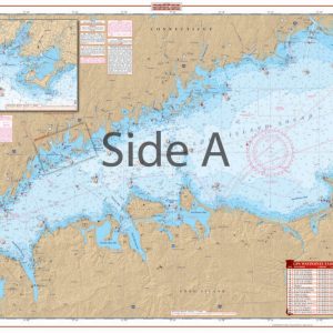
Coverage from Vermillion, Ohio north to Canada and west to Toledo on one side, including all the islands of Lake Erie and Port Clinton. The reverse side covers the Detroit River north to Belle Isle and Detroit. Detailed blown up insets for Bolles Harbor, North Shor…
The Area Covered
Coverage from Vermillion, Ohio north to Canada and west to Toledo on one side, including all the islands of Lake Erie and Port Clinton. The reverse side covers the Detroit River north to Belle Isle and Detroit. Detailed blown up insets for Bolles Harbor, North Shores, Toledo, Port Clinton and Monroe Harbor. ;A total of 8 GPS Waypoints are printed directly on the chart. Large place names make areas easy to find. A colored key makes chart easy to understand. Information from 4 NOAA Charts: #14848, #14847, #14846, & #14830. Chart is 25" X 38". WGS84 - World Mercator Datum.
Additional information
| Dimensions | 24 × 36 in |
|---|