Cape Coral Canals Large Print Navigation Chart 7E
The Area Covered
$32.95
Terrific coverage of the canals of the city of Cape Coral. The south side covers the Caloosahatchee River from Shell Point north to the new Midpoint Bridge and all canals and lakes north to Veterans Parkway. The reverse side covers all canals north from Veterans Parkway to Kismet Parkway noted with their names. Each canal is defined with a color scheme to indicate A) Sailboat Canals (not bridged); B) Powerboat Canals (bridged); and C) Fresh Water Canals (not linked navigationally to salt water). In addition, all bridge heights are shown establishing clearance requirements.
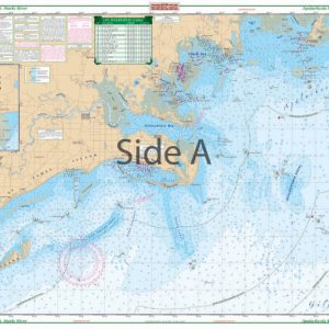
The Area Covered
Terrific coverage of the canals of the city of Cape Coral. The south side covers the Caloosahatchee River from Shell Point north to the new Midpoint Bridge and all canals and lakes north to Veterans Parkway. The reverse side covers all canals north from Veterans Parkway to Kismet Parkway noted with their names. Each canal is defined with a color scheme to indicate A) Sailboat Canals (not bridged); B) Powerboat Canals (bridged); and C) Fresh Water Canals (not linked navigationally to salt water). In addition, all bridge heights are shown establishing clearance requirements. Major roads and city facilities such as locks, lifts, and weirs, as well as parks, schools, and hospitals are shown. Boat ramps are located in both fresh and salt water areas and there is a location and phone number for each marina within the area of coverage. The river and Matlacha Pass areas are described with a simplified system of markers which makes the chart very easy to use. Terrific coverage of the Cape Coral canals is offered only by this navigation map. The south side covers the Caloosahatchee River from Shell Point north to the new Midpoint Bridge and all canals and lakes north to Veterans Parkway. The reverse side covers all Cape Coral canals north from Veterans Parkway to Kismet Parkway noted with their names. Each canal is defined with a color scheme to indicate A) Sailboat Canals (not bridged); B) Powerboat Canals (bridged); and C) Fresh Water Canals (not linked navigationally to salt water). In addition, all bridge heights are shown establishing clearance requirements. Major roads and city facilities such as locks, lifts, and weirs, as well as parks, schools, and hospitals are shown. Boat ramps are located in both fresh and saltwater areas and there is a location and phone number for each marina within the area of coverage. The river and Matlacha Pass areas are described with a simplified system of markers which makes the marine map very easy to use. Besides being excellent for navigation, this nautical map makes the perfect gift or framed piece of wall art. Information from NOAA chart #11427, Lee County GIS, private sources and field work. Nautical Chart is 25" X 38". WGS84 - World Mercator Datum.
Additional information
| Dimensions | 24 × 36 in |
|---|