Fishers Island Sound Navigation Chart 60
The Area Covered
$32.95
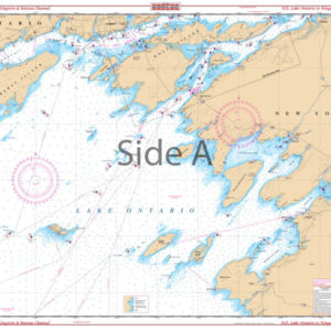
A great combination of 5 government charts. This chart provides good detail from Watch Hill west through Fishers Island Sound to the Thames River and upriver to north of Bartlett Point. The chart includes the Pawcatuck River, Stonington, Mystic Harbor, Noank and New London Harbor, and all of Fishers Island. The reverse side covers the Block Island Sound area including Plum Island and Gardiners Island, and Block Island west to Niantic and east to Newport, Rhode Island. Includes information from NOAA Charts: #13218, #13205, #13214, #13212, and #13372. This nautical map is comprised of 5 NOAA charts.
The Area Covered
A great combination of 5 government charts. This chart provides good detail from Watch Hill west through Fishers Island Sound to the Thames River and upriver to north of Bartlett Point. The chart includes the Pawcatuck River, Stonington, Mystic Harbor, Noank and New London Harbor, and all of Fishers Island. The reverse side covers the Block Island Sound area including Plum Island and Gardiners Island, and Block Island west to Niantic and east to Newport, Rhode Island. Includes information from NOAA Charts: #13218, #13205, #13214, #13212, and #13372. This nautical map is comprised of 5 NOAA charts. You won't find more detail than this in any other navigation chart. This navigation map provides pristine detail from Watch Hill RI west through Fishers Island Sound to the Thames River and upriver to north of Bartlett Point. The chart includes the Pawcatuck River, Stonington, Mystic Harbor, Noank and New London Harbor, and all of Fishers Island. The reverse side covers the Block Island Sound area including Plum Island and Gardiners Island, and Block Island west to Niantic and east to Newport, Rhode Island. This is an excellent chart for plotting a nautical journey, giving as a gift, or framing and displaying in your home or office. Includes information from NOAA Charts: #13218, #13205, #13214, #13212, and #13372. Nautical Chart is 25" X 38". WGS84 - World Mercator Datum.
Additional information
| Dimensions | 24 × 36 in |
|---|