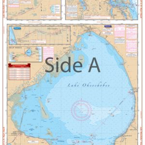
Lake Ontario – Northeast Lake Ontario Navigation Chart 76
The Area Covered
$32.95
Entire lake coverage from Kingston to Hamilton on one side, with 35 GPS Waypoints indexed and indicated on the chart. Provides detailed coverage of the northeast section of the lake from Stony Point west to False Ducks Islands and north to Kingston and east to Clayton. Covers the Cape Vincent Area and the popular Sacketts Harbor and Henderson Harbor areas. A total of 16 GPS Waypoints are printed directly on the chart.
Out of stock
The Area Covered
Entire lake coverage from Kingston to Hamilton on one side, with 35 GPS Waypoints indexed and indicated on the chart. Provides detailed coverage of the northeast section of the lake from Stony Point west to False Ducks Islands and north to Kingston and east to Clayton. Covers the Cape Vincent Area and the popular Sacketts Harbor and Henderson Harbor areas. A total of 16 GPS Waypoints are printed directly on the chart. Don't head out on the water without this Lake Ontario map. This marine map offers entire lake coverage from Kingston to Hamilton on one side, with 35 GPS Waypoints indexed and indicated. This navigation map provides detailed coverage of the northeast section of the lake from Stony Point west to False Ducks Islands and north to Kingston and east to Clayton. It also covers the Cape Vincent Area and the popular Sacketts Harbor and Henderson Harbor areas. A total of 16 GPS Waypoints are printed directly on this side. Plot your next journey with ease using this detailed navigation chart. The vibrant colors and design make this chart excellent for framing. Information from 2 NOAA Charts: #14802 and #14800. Nautical Chart is 25" X 38". WGS84 - World Mercator Datum.
Additional information
| Dimensions | 24 × 36 in |
|---|