Martha’s Vineyard and Nantucket Navigation Chart 10
The Area Covered
$32.95
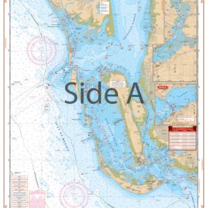
This double-sided, waterproof chart includes detailed coverage of both islands from Cuttyhunk Harbor east to Siasconset. There are details for Woods Hole and Menemsha Pond. The excellent colors and detail make this marine map especially suited for framing. Information comes from 3 NOAA charts: #13229, #13233, and #13241. This navigation chart is 25″ x 38″. WGS94- World Mercator Datum.
The Area Covered
Detailed coverage of both islands from Cuttyhunk Harbor east to Siasconset. Details for Woods Hole and Menemsha Pond. Information from 3 NOAA Charts: #13229, #13233 and #13241. You don't want to boat this popular summer area without this Martha's Vineyard map. This navigation chart offers detailed coverage of both Martha's Vineyard and Nantucket. These nautical charts run from Cuttyhunk Harbor east to Siasconset. There are details for Woods Hole and Menemsha Pond. The excellent colors and detail make this marine map especially suited for framing. Information comes from 3 NOAA charts: #13229, #13233, and #13241. This navigation chart is 25" x 38". WGS94- World Mercator Datum.
Additional information
| Dimensions | 24 × 36 in |
|---|