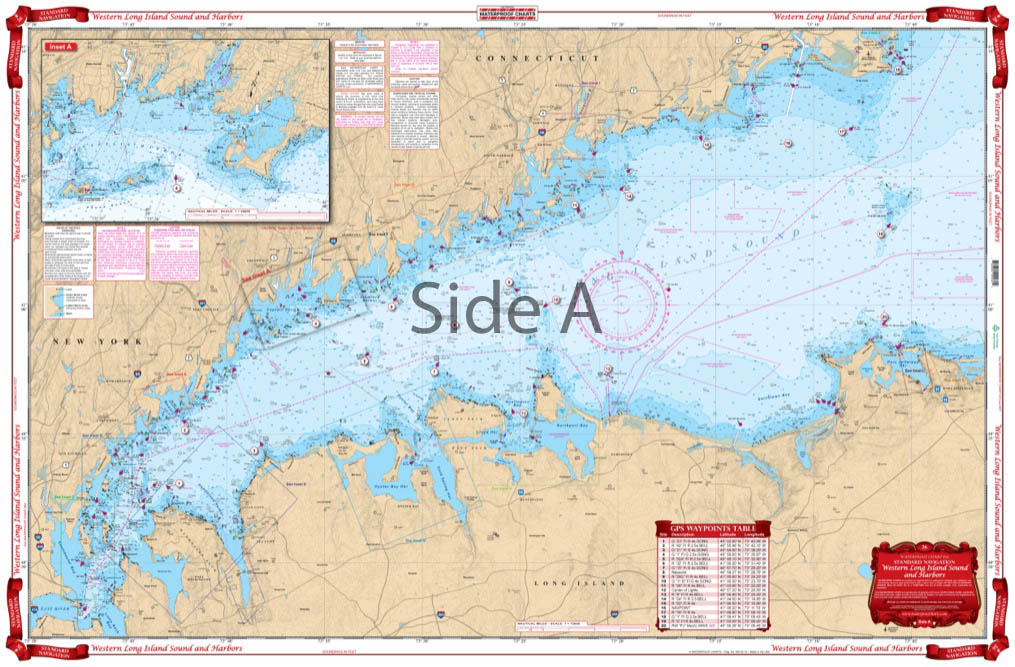
Western Long Island Sound and Harbors Navigation Chart 26
The Area Covered
$32.95
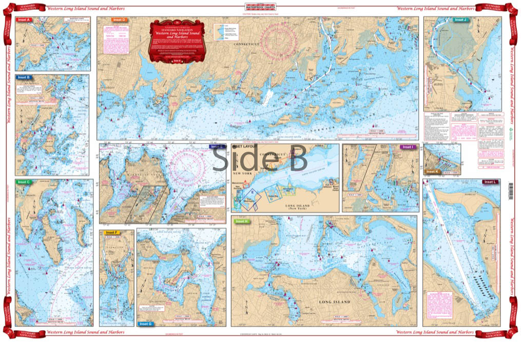
Overall coverage from the Throgs Neck Bridge to Stratford Point, CT and Port Jefferson, NY. A total of 13 harbor details for Captains Harbor, Mamaroneck, New Rochelle, City Island, Noroton and Norwalk, Manhassett and Hempstead Harbor, Stamford, Oyster Bay, Huntington and Northport Harbors, Westport and Saugatuck, Stratford, Mt. Sinai, and Port Jefferson Harbor. A colored key makes insets and harbors very easy to find. 11 GPS positions are printed directly on the chart.
The Area Covered
Overall coverage from the Throgs Neck Bridge to Stratford Point, CT and Port Jefferson, NY. A total of 13 harbor details for Captains Harbor, Mamaroneck, New Rochelle, City Island, Noroton and Norwalk, Manhassett and Hempstead Harbor, Stamford, Oyster Bay, Huntington and Northport Harbors, Westport and Saugatuck, Stratford, Mt. Sinai, and Port Jefferson Harbor. A colored key makes insets and harbors very easy to find. 11 GPS positions are printed directly on the chart. Large print place names make areas easy to find. Nobody has a better western Long Island Sound map. We take information derived from 4 NOAA charts to create the most detailed navigation map on the market. Overall coverage runs from the Throgs Neck Bridge to Stratford Point, CT and Port Jefferson, NY. There are a total of 13 harbor details for Captains Harbor, Mamaroneck, New Rochelle, City Island, Noroton and Norwalk, Manhassett and Hempstead Harbor, Stamford, Oyster Bay, Huntington and Northport Harbors, Westport and Saugatuck, Stratford, Mt. Sinai, and Port Jefferson Harbor. A colored key on this map of Long Island Sound makes insets and harbors very easy to find. 11 GPS positions are printed directly on the chart to help you find points of interest. Large print place names make areas easy to find, no matter if you are on a kayak, boat, or jetski. Grab a second navigation chart to have custom framed to place on your office or home wall. Information from 4 NOAA charts: 11363,12354, 12364,12368. Nautical chart is 24" X 36". WGS84 - World Mercator Datum.
Additional information
| Weight | 0.2 oz |
|---|---|
| Dimensions | 24 × 36 in |