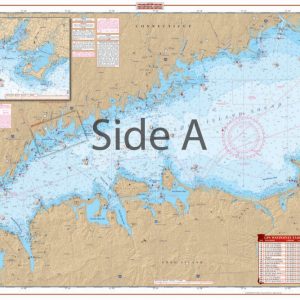
Point Sur to Drakes Bay Navigation Chart 84
The Area Covered
$32.95
Offshore coverage from Pt. Reyes south to Pt. Sur and offshore, past the Farallons to 123 degrees, 30 minutes west longitude. Coastal coverage with good detail from Drakes Bay south to Half Moon Bay, including the Farallons. Details for Half Moon Bay and Princeton, Southeast Farallon, Santa Cruz, Drakes Bay, Moss Landing Harbor, and Monterey Harbor. A total of 26 GPS Waypoints are indexed and plotted. Colored designators for harbor details make areas easy to find. Easily plan a trip between Point Reyes and Point Sur with this navigation chart.
The Area Covered
Offshore coverage from Pt. Reyes south to Pt. Sur and offshore, past the Farallons to 123 degrees, 30 minutes west longitude. Coastal coverage with good detail from Drakes Bay south to Half Moon Bay, including the Farallons. Details for Half Moon Bay and Princeton, Southeast Farallon, Santa Cruz, Drakes Bay, Moss Landing Harbor, and Monterey Harbor. A total of 26 GPS Waypoints are indexed and plotted. Colored designators for harbor details make areas easy to find. Easily plan a trip between Point Reyes and Point Sur with this navigation chart. Offshore coverage runs from Point Reyes south to Point Sur and offshore, past the Farallons to 123 degrees, 30 minutes west longitude. Coastal coverage provides detail from Drakes Bay south to Half Moon Bay, including the Farallons. Details are also included for Half Moon Bay and Princeton, Southeast Farallon, Santa Cruz, Drakes Bay, Moss Landing Harbor, and Monterey Harbor. A total of 26 GPS Waypoints are indexed and plotted on this marine map for your convenience. Colored designators for harbor details make areas easy to find. You won't find a more detailed chart than this Point Reyes map. Information from 5 NOAA Charts: #18687, #18645, #18682, #18680, and #18685. Nautical Chart is 25" X 38". WGS84 - World Mercator Datum.
Additional information
| Dimensions | 24 × 36 in |
|---|