Lake Pontchartrain to Gulfport Inshore Fishing Chart 140F
$32.95
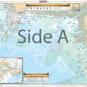
Complete coverage of Lake Ponchartrain and Lake Maurepas, through Chef Menteur Pass and the intracoastal waterway to the Rigolets and Lake Borgne. Includes Mississippi Sound and the Ship Island Area. Details for Gulfport and the Rigolets as well as the Inner Harbor Navigation Canal in New Orleans.
THIS IS A FOLDED CHART. CAN BE SHIPPED ROLLED UPON REQUEST.
Complete coverage of Lake Ponchartrain and Lake Maurepas, through Chef Menteur Pass and the intracoastal waterway to the Rigolets and Lake Borgne. Includes Mississippi Sound and the Ship Island Area. Details for Gulfport and the Rigolets as well as the Inner Harbor Navigation Canal in New Orleans. This chart details all of the major fishing areas and pinpoints dozens of specific areas for the major species caught in the area (Seatrout, Redfish, Flounder, Drum, Whitetrout, Jack Carvelle, Tripletail, Channel Catfish, Tarpon, Crappie, and Sheepshead). Each area where fish are found have GPS positions. Reef Ball Areas, Marsh & Grass Areas are listed as well as known bait areas. Also included is a GPS Waypoint Table. Marinas are listed as well as popular Boat Ramps. We would like to thank Capt. Damien Perez & Capt. Mike Gallo for their help with this chart. . Lake Pontchartrain fishing is now easier than ever (and more fun!). You will spend less time hunting for fish with all the fishing locations we have placed on this navigation chart. Complete coverage of Lake Pontchartrain and Lake Maurepas, through Chef Menteur Pass and the intracoastal waterway to the Rigolets and Lake Borgne. Includes Mississippi Sound and the Ship Island Area. Details for Gulfport and the Rigolets as well as the Inner Harbor Navigation Canal in New Orleans are included on this navigation map. This chart details all of the major fishing areas and pinpoints dozens of specific areas for the major species caught in the area (Seatrout, Redfish, Flounder, Drum, Whitetrout, Jack Carvelle, Tripletail, Channel Catfish, Tarpon, Crappie, and Sheepshead). Each area where fish are found have GPS positions. Reef ball areas, marsh & grass areas are listed as well as known bait areas. Also included is a GPS Waypoint Table to help you easily input coordinates into your GPS unit. Marinas are listed as well as popular boat ramps. Get this marine map framed and proudly display it on your wall. We would like to thank Capt. Damien Perez & Capt. Mike Gallo for their help with this chart. Nautical Chart is 25" X 38". WGS84 - World Mercator Datum.
Additional information
| Weight | .167 oz |
|---|---|
| Dimensions | 24 × 36 in |