Middle Keys to Sanibel Maxi Navigation Chart 3
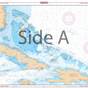
The Area Covered
$32.95
A creative splice of three NOAA charts combined with a general area offshore chart – fills the chart gap north of the middle and lower keys. The offshore side covers the area from Sanibel south to the Marquesas, Key West and Marathon with 22 GPS Waypoints for easy navigation. The inshore, southern side combines three coastal charts to give continuous coverage from Cape Sable along the western National Park Boundary south to Marathon, and west to the Content and Sawyer Keys. 28 GPS waypoints for nav aids and numerous wrecks, fishing and lobster spots. When we say we have the best nautical charts on the market, we mean it.
The Area Covered
A creative splice of three NOAA charts combined with a general area offshore chart - fills the chart gap north of the middle and lower keys. The offshore side covers the area from Sanibel south to the Marquesas, Key West and Marathon with 22 GPS Waypoints for easy navigation. The inshore, southern side combines three coastal charts to give continuous coverage from Cape Sable along the western National Park Boundary south to Marathon, and west to the Content and Sawyer Keys. 28 GPS waypoints for nav aids and numerous wrecks, fishing and lobster spots. When we say we have the best nautical charts on the market, we mean it. We spend countless hours going into the field (or should we say water) to get to know the area. We also speak to locals who make their living on the water to get their tips and secrets. This navigation chart is a creative splice of three NOAA charts combined with a general offshore chart. It fills the chart gap north of the middle and lowers Florida Keys. The offshore side covers the area from Sanibel south to the Marquesas, Key West and Marathon with 22 GPS Waypoints for easy navigation. The inshore, southern side combines three coastal marine charts to give continuous coverage from Cape Sable along the western National Park Boundary south to Marathon, and west to the Content and Sawyer Keys. There are 28 GPS waypoints for navigation aids and numerous wrecks, fishing and lobster spots. This chart is a great addition to any Florida Keys fishing trip, and to remember this trip, we offer framing services for all of our navigation charts. Information from 4 NOAA charts: #11442, #11452, #11431 and #11420. A total of 50 GPS Waypoints. Nautical chart is 25" X 38". WGS84 - World Mercator Datum.
Additional information
| Weight | 0.2 oz |
|---|---|
| Dimensions | 24 × 36 in |