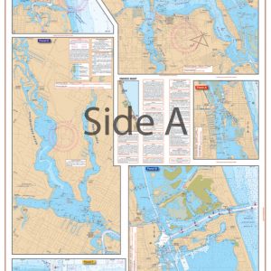
San Joaquin River and Delta Navigation Chart 79
The Area Covered
Original price was: $32.95.$22.95Current price is: $22.95.
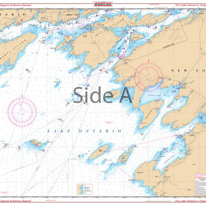
From Vallejo and Mare Island, this chart covers the Sacramento River to Sherman Island, the Suisun Slough to Suisun City, and the Napa River to Suscol with details of Pittsburg and Antioch on side A. Side B follows th San Joaquin upstream to Stockton and covers the many channels both north of Stockton to Staten Island and south to El Pescadero and Mossdale. Fueling facilities are indicated by over 50 added red designators. Colored chart key and large print place names makes this chart easy to use. A detailed inset for the State Highway 160 bridge area has been added.
The Area Covered
From Vallejo and Mare Island, this chart covers the Sacramento River to Sherman Island, the Suisun Slough to Suisun City, and the Napa River to Suscol with details of Pittsburg and Antioch on side A. Side B follows th San Joaquin upstream to Stockton and covers the many channels both north of Stockton to Staten Island and south to El Pescadero and Mossdale. Fueling facilities are indicated by over 50 added red designators. Colored chart key and large print place names makes this chart easy to use. A detailed inset for the State Highway 160 bridge area has been added. Traversing the rivers of California by boat, kayak, paddleboard, or jetski is now much easier with this navigation chart. From Vallejo and Mare Island, this nautical map covers the Sacramento River to Sherman Island, the Suisun Slough to Suisun City, and the Napa River to Suscol with details of Pittsburg and Antioch on side A. Side B follows th San Joaquin upstream to Stockton and covers the many channels both north of Stockton to Staten Island and south to El Pescadero and Mossdale. Fueling facilities are indicated by over 50 red designators. A detailed inset for the State Highway 160 bridge area has been added to this marine map. Colored chart key and large print place names makes this Sacramento River map easy to use and excellent for framing. Information from 4 NOAA Charts: #18651, #18654, #18656, and #18652. Nautical Chart is 25" X 38". WGS84 - World Mercator Datum.
Additional information
| Dimensions | 24 × 36 in |
|---|