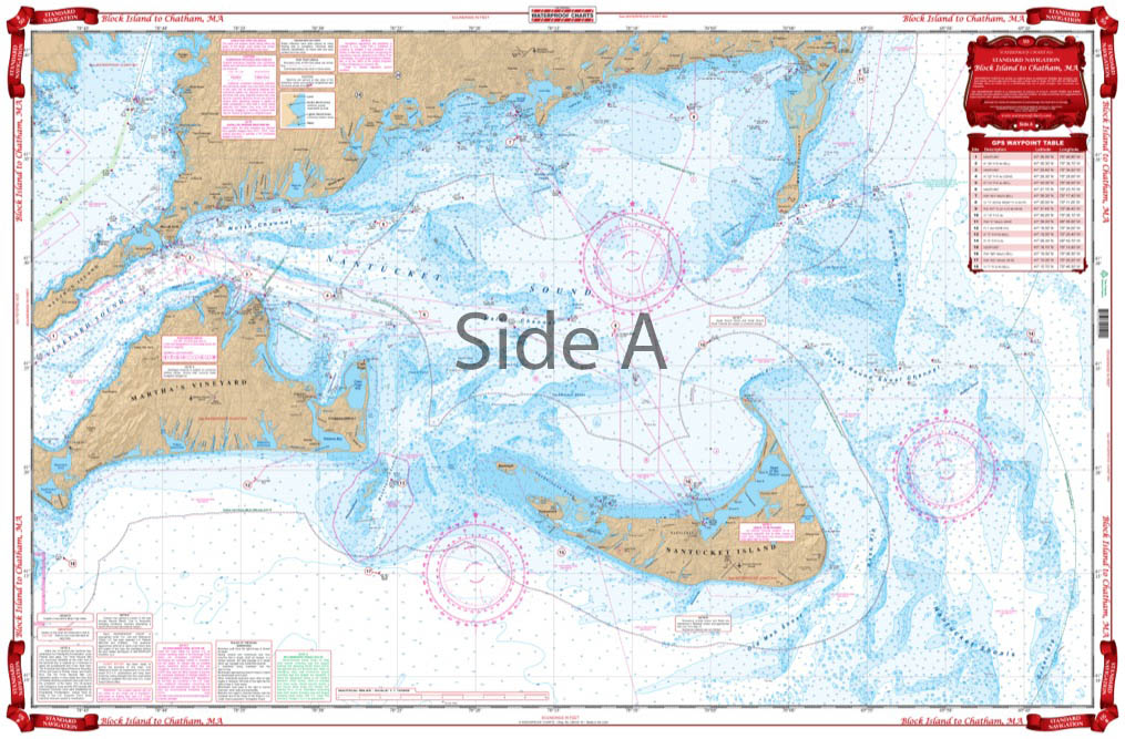

Block Island to Chatham Navigation Chart 50
The Area Covered
$32.95
Covers Rhode Island Sound from Block Island east to Martha’s Vineyard and Woods Hole on the west panel. Continues from Martha’s Vineyard East to Nantucket and Monomoy Island and Chatham Harbor on the east panel.
The Area Covered
Covers Rhode Island Sound from Block Island east to Martha's Vineyard and Woods Hole on the west panel. Continues from Martha's Vineyard East to Nantucket and Monomoy Island and Chatham Harbor on the east panel. Coverage includes southeast Buzzards Bay North to West Falmouth, and the Sakonnet River, north to High Hill Point, and Southern Narragansett Bay to Newport Neck. GPS Waypoints are printed directly on the chart. Boat this New England area with ease using this detailed nautical map. This navigation map is durable and tear resistant, making it excellent for using on any vessel: boat, kayak, paddleboard, jetski. It covers Rhode Island Sound from Block Island east to Marthas Vineyard and Woods Hole on the west panel. The marine map continues from Marthas Vineyard East to Nantucket and Monomoy Island and Chatham Harbor on the east panel. Coverage includes southeast Buzzards Bay North to West Falmouth, and the Sakonnet River, north to High Hill Point, and Southern Narragansett Bay to Newport Neck. GPS Waypoints are printed directly on the navigation chart. You will find these vibrant colors make this chart perfect for framing. Information from 3 NOAA Charts: #13218, #13205 & #13237. Nautical Chart is 25" X 38". WGS84 - World Mercator Datum.
Additional information
| Dimensions | 24 × 36 in |
|---|